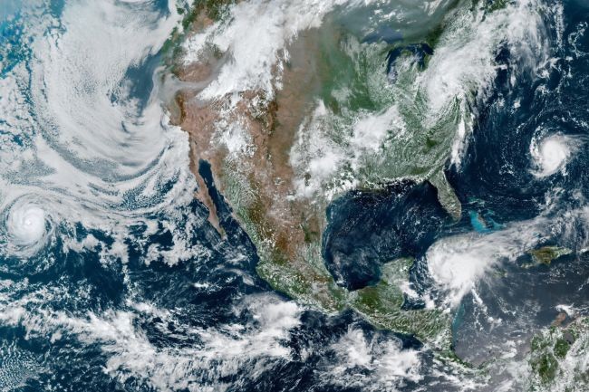
North America is currently surrounded by four different storms which were all captured in a single satellite imaging from space. The unexpected appearance of the storm cluster marks the beginning of the hurricane season on the continent this year.
Storm Cluster Hits North America

The Geostationary Operational Environmental Satellite 16, also known as GOES-16, was a NOAA satellite that captured the four massive storms over the skies of the North American continent. According to a report by Space, the aerial views include the tropical storms Fred and Henri, along with the super large hurricanes Grace and Linda. The imaging, captured last Wednesday, also includes some of the thick smoke emissions from the ongoing catastrophic wildfires located in the western regions of the United States.
NASA Earth Observatory reported that the group of storms present on the continent is a bit early compared to the expected annual arrival. The usual cycle of storm season in North America begins when the sea temperature increases during summer. Due to the warmer oceanic bodies, storms and cyclones were able to form easily.
GOES-16 is equipped with the Advanced Baseline Imager, which was the instrument that is responsible for capturing the 4 storms hovering over the North American skies. The storms, even though similar in appearance, are indifferent development phases.
ALSO READ : Supporting Evidence of Earth's 200-Million-Year Magnetic Field Cycle Discovered from Lava Flows
North America is Surrounded by Four Storms with Different Intensities; One Categorized as Devastating Annular Hurricane
Hurricane Grace is on the lower right of the image and is positioned over the country of Haiti. The hurricane currently brings flood and heavy rainfall to the victim of a 7.2 magnitude earthquake, which caused additional problems for the remaining victims. Along with Haiti, the Dominican Republic also experienced the effects of the said hurricane. After bringing down heavy rainfalls on the Caribbean countries, Hurrican Grace targetted the Yucatan peninsula of Mexico.
Linda, located on the western side of the image, still hovers over the Eastern Pacific region. The storm is considered a destructive type also known as the annular hurricane, running at over 200 kilometers per hour, and is expected to charge full-scale at landfall. Lind is reported to be far from touching any grounds yet but is already tagged as a category 4 hurricane by experts.
Tropical storm Fred is currently at the east coast of North America, and have gone through the regions of Florida. The storm expresses strong winds and scattered rainfalls that cause numerous flood incidents and minor tornadoes. Fred was recorded running at 105 kilometers per hour.
Henri was located at the far right of the satellite image and was spotted near the Bermuda regions. Experts said that the storm will continue to move towards the northeast of the continent, and impacts this weekend will occur on the coast of the specified region.
One of the storm clusters, Linda, might be the strongest among the spotted storms. Linda is tagged as an annular hurricane, a type of storm with an intensified features. NASA Goddard Space Flight Center expert Charles Helms said that annular hurricanes usually includes a collection of symmetrical eyes and are known to be resistant against external factors that could affect their peak performance.
Check out more news and information on Environment and Climate on Science Times.
© 2026 ScienceTimes.com All rights reserved. Do not reproduce without permission. The window to the world of Science Times.


