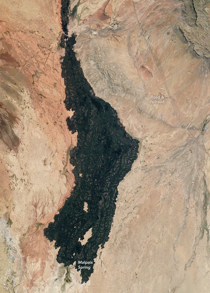
While in orbit over the Southwest of the United States, a NASA astronaut on the International Space Station took several pictures of the enormous basaltic lava flow known as the Carrizozo Malpa's in central New Mexico.
NASA said that the astronaut fused four images together to make the mosaic.

NASA Astronaut Finds Lava Flowing From New Mexico
Little Black Summit, a dormant cinder cone near Carrizozo Malpa's northernmost point, is the highest peak of the largest shield volcano.
NASA Earth Observatory, who also shared footage of the lava on YouTube, Little Black Peak had a vent that erupted approximately 5,000 years ago and lasted for many decades.
The episode resulted in the second youngest lava flow in New Mexico and one of the longest flows from the Holocene Epoch. It extends 50 miles (75 kilometers) over the Chihuahuan Desert, from its northernmost to southernmost points.
The lighter areas scattered throughout the flow represent either various lava structures, such as cracks, collapses, and depressions, or empty zones free of lava.
NASA observed that desert flora, including juniper trees, perennial flowers, and prickly pear cactus, could thrive inside these characteristics.
A road divides the top portion of the lava flow, and a train connects it to the town of Carrizozo. Just to the north of the White Sands Missile Range, Malpa's Spring is reached by the flow's southern side.

Space.com said the majority of the lava in the photograph came from a tiny, 27-meter-tall (88-foot) vent.
The vent is situated in the midst of the Capitan lineament, an area of crustal weakness where magma may readily ascend through the Earth's crust and erupt on the surface.
According to Earth Observatory, the irregular, textured look of the frozen lava is caused by light reflecting off fractures, collapses, and depressions in the volcanic rock. The northern end of the lava field is divided by the main road and a railroad.
Although the old lava field may appear dead from above, Earth Observatory reports that a variety of desert plant species, including juniper trees, perennial flowers, and prickly pear cactuses (Opuntia), may flourish in the frozen magma.
Who Captured the Photo?
According to NASA, a member of the Expedition 67 crew captured the images using a Nikon D5 digital camera using a focal length of 400 millimeters.
For the final photographs, lens artifacts have been removed, and contrast has been boosted and reduced.
The International Space Station Program supports the laboratory as part of the ISS National Lab to help astronauts capture Earth photos that will be most helpful to scholars and the general public.
RELATED ARTICLE : NASA's Hubble Space Telescope Finds Supergiant Star Betelgeuse Recovering From Blast
Check out more news and information on Space in Science Times.
© 2026 ScienceTimes.com All rights reserved. Do not reproduce without permission. The window to the world of Science Times.


