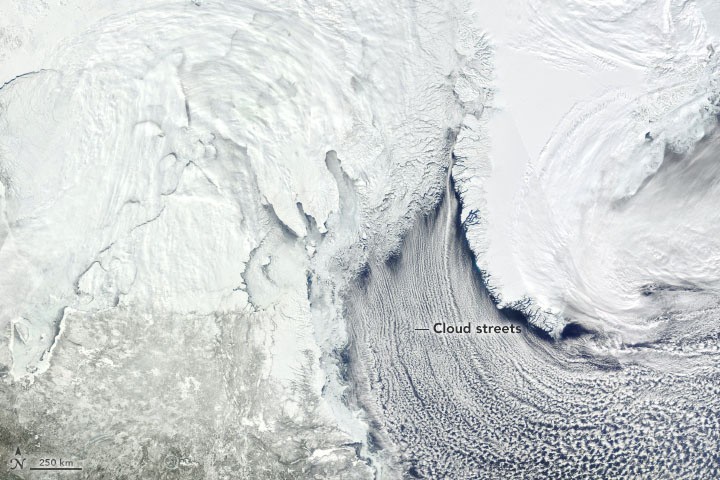
Sea ice thickness in the Labrador Sea has been below normal in recent months, National Snow and Ice Data Centre said.

According to a recent analysis, sea levels could increase by an Earth-changing 60 feet if the last Ice Age is any indicator.
News reports show the region's thin ice has raised several problems for Inuit inhabitants, including the destruction of ice highways that connect villages and provide access to hunting and wood-gathering areas.
What Has Been Happening to the Labrador Sea?
On March 27, 2021, NASA's Aqua satellite's Moderate Resolution Imaging Spectroradiometer (MODIS) captured a natural-color view of ice in the Labrador Sea. The sea is part of the North Atlantic Ocean and links to the Arctic Ocean by numerous straits and bays to the north. It is located between Greenland and Canada's Labrador Peninsula.
NASA's Earth Observatory said ice of different shapes and thicknesses contains the Labrador Peninsula's coast in the shot. In some areas, heavier, more consolidated ice still clings to the shore. A blend of fractured floes is floating in patches of unfrozen water off the coast of Canada's Nunavut province. Ocean winds sculpt the ice into cyclone-shaped vortices at the ice edge furthest from the shore.
But ice isn't the only white thing. Cloud streets are the long, parallel bands of white that run parallel to the Davis Strait. When cold air blows over comparatively warmer water in the spring, this kind of cumulus cloud is normal. Condensed water vapor will fly hundreds of kilometers, and in this situation, it swept all the way around Greenland's southern edge.
What Happens when a Huge Volume of Ice Melts?
Sea levels are threatening to upset the planet's natural equilibrium. Flooding and destruction are becoming more frequent in coastal cities and towns, and numerous wildlife species face the risk of destroying their entire natural environment.
Experts claim in a separate study that the rate of ice depletion has risen by 65 percent in the last 23 years. The polar ice sheets of Antarctica and Greenland held the majority of the missing ice.
ALSO READ : Oldest Antarctic Ice: Will Searching For An Older Ice Core Help Understand Earth's Climate?
In a university release, lead research author Dr. Thomas Slater said ice sheet declines from the Antarctic and Greenland had increased the most.
"The ice sheets are now following the worst-case climate warming scenarios set out by the Intergovernmental Panel on Climate Change. Sea-level rise on this scale will have very serious impacts on coastal communities this century."
What's Allowing the Ice to Melt Too Quickly?
Unsurprisingly, the constant warming of the planet's seas and climate is to blame for much of this massive ice depletion. Every decade since 1980, the Earth's oceans and atmosphere have warmed by more than 32 degrees Fahrenheit. Researchers said most melting ice (68 percent) was due to atmospheric warming, with the remainder due to oceanic warming.
The Arctic Sea (7.6 trillion tons) and Antarctic ice shelves are the most ice depletion areas (6.5 trillion tons). All of these float on the surface of the polar waters, which is interesting.
Dr. Isobel Lawrence, another research fellow at the Centre for Polar Observation and Simulation, said sea ice depletion does not directly contribute to sea-level increase. However, it does have an indirect impact.
One of the most essential purposes of Arctic sea ice, according to Lawrence, is to filter solar radiation back into space, which helps keep the Arctic cold.
According to the research fellow, as the sea ice melts, more solar radiation is consumed by the oceans and atmosphere, allowing the Arctic to warm faster than everywhere else on the globe.
Not only is this hastening the loss of sea ice, but it is also hastening the melting of glaciers and ice caps, causing sea levels to increase, according to Lawrence.
RELATED ARTICLE : Nations Are Now Flocking In On Antarctica
Check out more news and information on Climate Change on Science Times.


